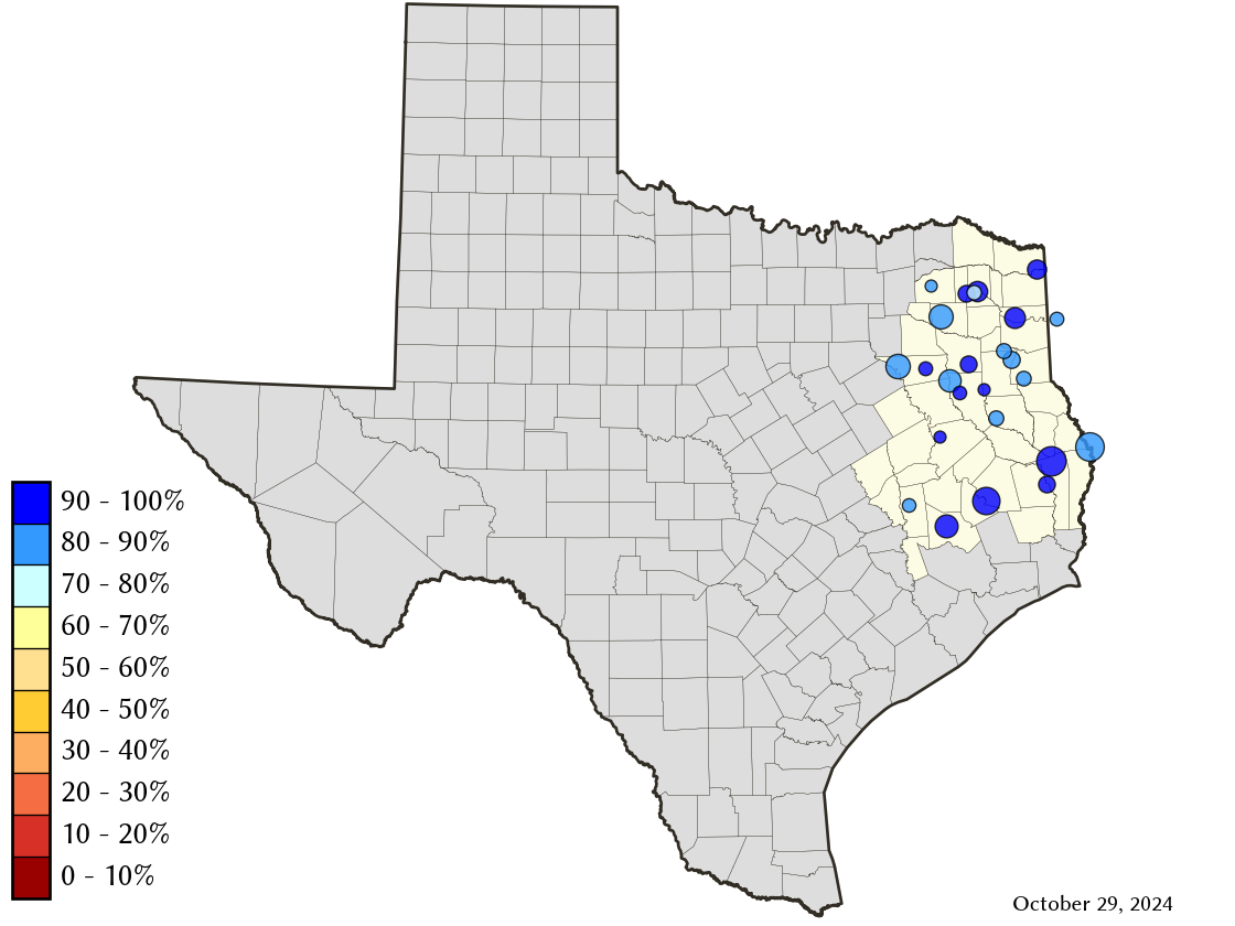
East-Texas Climate Division Reservoirs: Monitored Water Supply Reservoirs are 99.7% full on 2025-04-26
Historical Data
| Date | Percent Full |
Reservoir Storage (acre-ft) |
Conservation Storage (acre-ft) |
Conservation Capacity (acre-ft) |
|
|---|---|---|---|---|---|
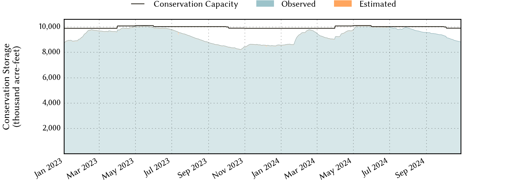
| Today | 2025-04-26 | 99.7 | 12,819,335 | 9,855,688 | 9,886,943 |
| Yesterday | 2025-04-25 | 99.7 | 12,838,015 | 9,857,978 | 9,886,943 |
| 2 days ago | 2025-04-24 | 99.6 | 12,832,376 | 9,848,992 | 9,886,943 |
| 1 week ago | 2025-04-19 | 99.2 | 12,884,398 | 9,803,264 | 9,886,943 |
| 1 month ago | 2025-03-26 | 98.2 | 12,159,040 | 9,712,675 | 9,886,943 |
| 3 months ago | 2025-01-26 | 95.7 | 11,872,137 | 9,460,998 | 9,886,943 |
| 6 months ago | 2024-10-26 | 89.4 | 10,997,881 | 8,846,528 | 9,899,419 |
| 1 year ago | 2024-04-26 | 96.3 | 12,390,075 | 9,702,495 | 10,074,732 |
*
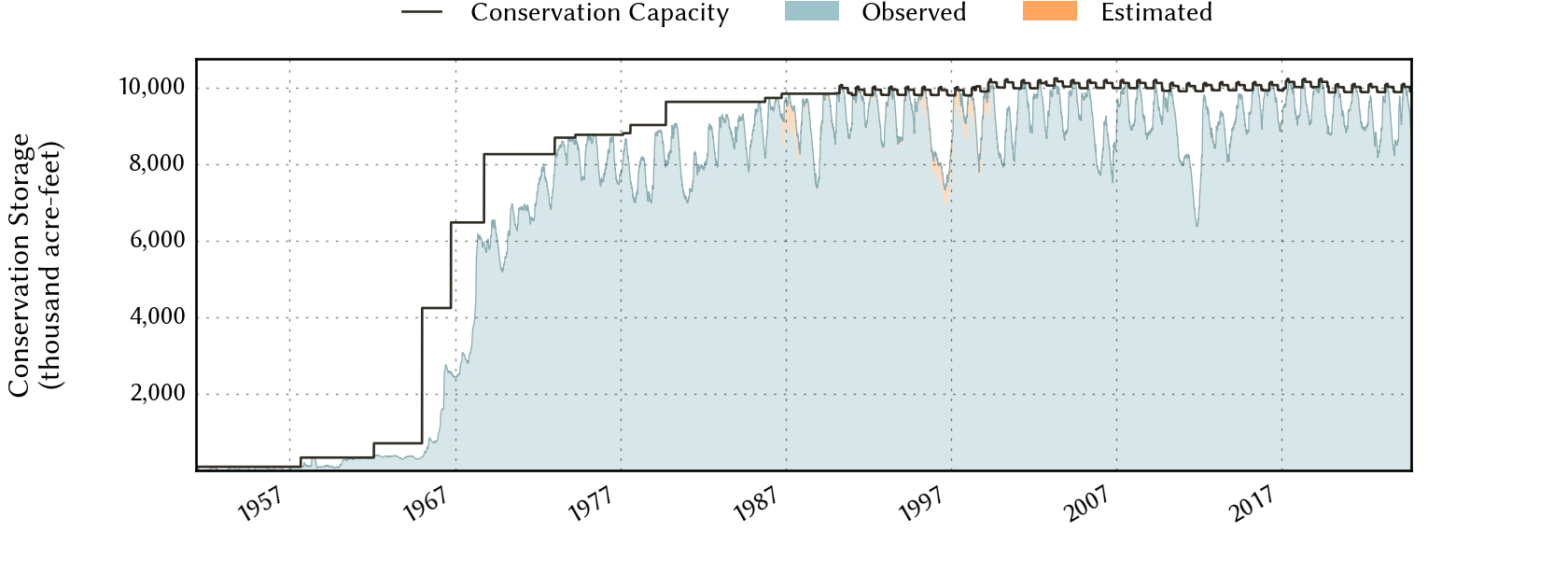
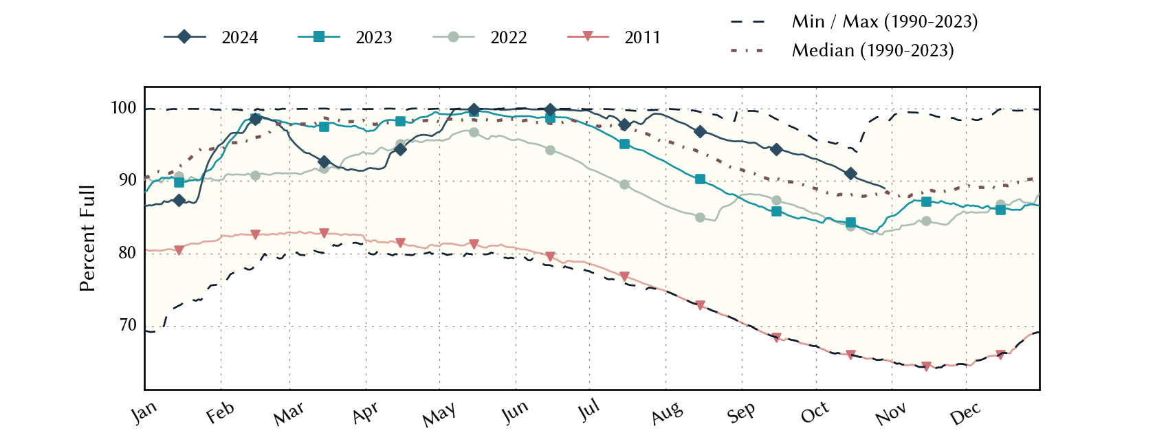
Percent Full is based on Conservation Storage and Conservation Capacity and doesn't account for storage in flood pool.
Area Map
Reservoir Storage
| Reservoir | Type | Percent Full |
Water Level (ft) |
Height Above Conservation Pool (ft) |
Reservoir Storage (acre-ft) |
Conservation Storage (acre-ft) |
Conservation Capacity (acre-ft) |
Surface Area (acres) |
|---|---|---|---|---|---|---|---|---|
| Athens |

|
100.0 | 440.39 | 0.39 | 30,275 | 29,503 | 29,503 | - n.a. - |
| B A Steinhagen |
|
96.3 | 82.75 | -0.25 | 66,731 | 66,658 | 69,186 | 10,005 |
| Bob Sandlin |
|
100.0 | 337.75 | 0.25 | 205,376 | 192,417 | 192,417 | 8,937 |
| Caddo 1 |
|
100.0 | 169.76 | 1.26 | 161,612 | 29,898 | 29,898 | 29,552 |
| Cedar Creek |
|
100.0 | 322.09 | 0.09 | 647,732 | 644,686 | 644,686 | - n.a. - |
| Cherokee |
|
100.0 | 280.30 | 0.30 | 46,031 | 40,094 | 40,094 | - n.a. - |
| Conroe |
|
100.0 | 201.14 | 0.14 | 420,996 | 417,577 | 417,577 | 20,515 |
| Cypress Springs |
|
100.0 | 378.52 | 0.52 | 68,447 | 66,756 | 66,756 | - n.a. - |
| Fork |
|
99.2 | 402.81 | -0.19 | 631,483 | 600,040 | 605,061 | 26,304 |
| Gibbons Creek |
|
81.3 | 244.97 | -2.03 | 22,604 | 20,900 | 25,721 | 2,203 |
| Houston County |
|
100.0 | 260.45 | 0.45 | 18,251 | 17,113 | 17,113 | - n.a. - |
| Jacksonville |
|
100.0 | 422.26 | 0.26 | 26,035 | 25,670 | 25,670 | - n.a. - |
| Lake O' the Pines |

|
100.0 | 233.31 | 4.81 | 333,928 | 241,363 | 241,363 | - n.a. - |
| Livingston |
|
100.0 | 131.21 | 0.21 | 1,619,935 | 1,603,504 | 1,603,504 | - n.a. - |
| Martin |
|
99.8 | 305.97 | -0.03 | 75,578 | 75,578 | 75,726 | 4,949 |
| Monticello |
|
86.6 | 337.60 | -2.40 | 30,100 | 30,100 | 34,740 | 1,784 |
| Murvaul |
|
100.0 | 265.61 | 0.31 | 39,354 | 38,285 | 38,285 | - n.a. - |
| Nacogdoches |
|
100.0 | 279.49 | 0.49 | 40,605 | 39,522 | 39,522 | - n.a. - |
| Palestine |
|
100.0 | 345.29 | 0.29 | 374,053 | 367,303 | 367,303 | - n.a. - |
| Sam Rayburn |
|
100.0 | 164.61 | 0.21 | 2,899,724 | 2,857,077 | 2,857,077 | - n.a. - |
| Striker |
|
99.1 | 292.92 | -0.08 | 21,643 | 16,721 | 16,878 | 1,948 |
| Sulphur Springs |
|
83.3 | 457.25 | -1.70 | 14,781 | 14,781 | 17,747 | - n.a. - |
| Toledo Bend 2 |
|
99.5 | 171.78 | -0.22 | 4,455,052 | 2,225,476 | 2,236,450 | 181,439 |
| Tyler |
|
100.0 | 375.64 | 0.26 | 78,518 | 72,073 | 72,073 | - n.a. - |
| Wright Patman |
|
100.0 | 232.17 | 11.57 | 490,491 | 122,593 | 122,593 | - n.a. - |
footnotes
1
Caddo Lake straddles the border of Texas and Louisiana, Texas has rights to 50% of Lake Caddo's total conservation capacity. Percent full, conservation storage and conservation capacity are based on the Texas share.
2
Toledo Bend Reservoir straddles the border of Texas and Louisiana, Texas has rights to 50% of Toledo Bend Reservoir's total conservation capacity. Percent full, conservation storage and conservation capacity are based on the Texas share.